

The Hidden Forces Behind Earthquakes and Tsunamis
A Scientific Inquiry into Earth's Most Destructive Phenomena

ABSTRACT
Beneath the placid surface of our world lies an engine of immense, barely contained power. Earthquakes and tsunamis — among the most catastrophic natural events on Earth — are not random acts of geological caprice. They are the inevitable, measurable consequences of planetary-scale forces operating across deep time. This essay examines the geophysical mechanisms that drive seismic activity and oceanic megawaves: the architecture of tectonic plates, the thermodynamics of the mantle, the physics of fault rupture, and the fluid dynamics of tsunami propagation. Understanding these hidden forces is not merely an academic exercise — it is a prerequisite for building a civilization resilient enough to survive them.
A Planet in Perpetual Motion: The Tectonic Framework
Earth is not the static, solid sphere it appears to be from the vantage of human lifespans. Viewed across geological time, it is a dynamic, churning system — a thin rocky shell fragmented into enormous interlocking pieces, drifting ceaselessly atop a semi-molten interior. These fragments, the tectonic plates, are the fundamental actors in the drama of earthquakes and tsunamis.
1.1 The Structure of a Restless Planet
To understand seismic forces, one must first understand Earth’s layered architecture. The innermost core — a solid iron-nickel sphere roughly 1,220 kilometers in radius — is surrounded by a liquid outer core whose convective motion generates Earth’s magnetic field. Above this lies the mantle, a layer nearly 2,900 kilometers thick composed primarily of silicate minerals. Though largely solid on human timescales, the mantle behaves as an extremely viscous fluid over millions of years, flowing and circulating in vast convection cells driven by residual heat from Earth’s formation and ongoing radiogenic decay.
Atop this flowing mantle sits the lithosphere — the rigid outermost shell comprising both the crust and the uppermost, cooler portion of the mantle. The oceanic lithosphere, dense and relatively thin (5 to 10 kilometers of basaltic crust), contrasts sharply with the continental lithosphere, which is thicker (up to 70 kilometers) and less dense. The lithosphere is fractured into approximately 15 major plates and numerous smaller microplates, all in motion relative to one another.
1.2 The Engine Beneath: Mantle Convection and Slab Pull
The driving forces of plate tectonics have been debated for decades, but modern geophysics recognizes two dominant mechanisms. The first is mantle convection: heat rising from the deep interior creates circulation cells in the mantle that drag the overlying plates. The second, and now considered more powerful, is slab pull — when an old, cold, dense oceanic plate subducts beneath another plate, its sheer weight drags the rest of the plate behind it like a tablecloth pulled over an edge.
The convergence of these forces at plate boundaries creates zones of extraordinary mechanical stress. Where plates collide, separate, or grind past one another, the accumulated strain is periodically released in the form of earthquakes — sometimes of staggering magnitude. These boundaries are not abstract lines on a map; they are corridors of geological violence running for thousands of kilometers through the ocean floors and across continents.
The Mechanics of Seismic Rupture
An earthquake is, at its essence, the sudden release of elastic energy stored in rock. Understanding why and how this release occurs requires delving into the physics of brittle rock deformation and the behavior of fault systems under extreme stress.
2.1 Faults, Stress, and the Elastic Rebound Theory
A fault is a fracture or zone of fractures in Earth’s crust along which blocks of rock have moved relative to one another. Faults come in several geometries, each associated with different stress regimes. Strike-slip faults, such as California’s San Andreas Fault, involve horizontal motion. Normal faults form where the crust is being pulled apart. Reverse and thrust faults form where plates converge, and one block overrides another — and it is these thrust faults that are most capable of generating the world’s greatest earthquakes and tsunamis.
The prevailing scientific explanation for earthquake generation is the elastic rebound theory, first formalized by Harry Fielding Reid following the 1906 San Francisco earthquake. According to this model, tectonic forces gradually deform the rocks surrounding a fault, storing elastic strain energy much as a compressed spring stores mechanical energy. As long as friction holds the fault locked, no motion occurs. But stress accumulates inexorably. When the shear stress on the fault finally exceeds its frictional strength, the fault ruptures catastrophically, the locked blocks rebound to their pre-stressed geometry, and the released energy radiates outward as seismic waves.
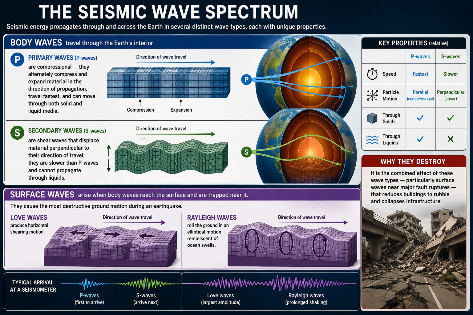
2.2 The Seismic Wave Spectrum
Seismic energy propagates through and across the Earth in several distinct wave types, each with unique properties. Body waves travel through the Earth’s interior and include two subtypes: Primary waves (P-waves) are compressional — they alternately compress and expand material in the direction of propagation, travel fastest, and can move through both solid and liquid media. Secondary waves (S-waves) are shear waves that displace material perpendicular to their direction of travel; they are slower than P-waves and cannot propagate through liquids.
Surface waves, which arise when body waves reach the surface and are trapped near it, cause the most destructive ground motion during an earthquake. Love waves produce horizontal shearing motion; Rayleigh waves roll the ground in an elliptical motion reminiscent of ocean swells. It is the combined effect of these wave types — particularly surface waves near major fault ruptures — that reduces buildings to rubble and collapses infrastructure.
2.3 Measuring the Unmeasurable: Magnitude and Intensity
Seismic magnitude scales have evolved considerably since Charles Richter introduced his logarithmic local magnitude scale in 1935. Today, the preferred scientific measure is the moment magnitude scale (Mw), which is calculated from the seismic moment — the product of the rock’s shear modulus, the area of the fault rupture, and the average displacement along it. Each whole-number increase in Mw corresponds to approximately 31.6 times more energy release. The 2011 Tōhoku earthquake (Mw 9.1) released roughly 9,000 times the energy of the 1995 Kobe earthquake (Mw 6.9) — a sobering illustration of the scale’s exponential nature.
Intensity, distinct from magnitude, measures the local effects of an earthquake at a given location. The Modified Mercalli Intensity scale, ranging from I (imperceptible) to XII (destruction), captures the spatially variable human experience of a seismic event — a reminder that the destructive power of any earthquake is shaped not only by its raw energy but by distance, local geology, and building stock.
Subduction Zones: Where Giants Are Born
Not all plate boundaries are created equal in their capacity for destruction. The most seismically potent environments on Earth are subduction zones — regions where oceanic plates dive beneath continental or other oceanic plates at convergent margins. These are the nurseries of megathrust earthquakes and the birthplaces of tsunamis.
3.1 The Geometry of Subduction
As an oceanic plate subducts, it does not slide smoothly into the mantle. Instead, the interface between the descending slab and the overriding plate — the megathrust fault — becomes locked as the two plates couple together. Sediments and water dragged down with the subducting slab lower the effective normal stress on the fault, modulating where and how it locks. Over decades to centuries, strain accumulates until the megathrust suddenly slips, sometimes by tens of meters over rupture lengths of hundreds or thousands of kilometers.
The world’s most powerful earthquakes have all occurred at subduction zones. The 1960 Valdivia earthquake (Mw 9.5) ruptured approximately 1,000 kilometers of the Chile Trench. The 2004 Indian Ocean earthquake (Mw 9.1–9.3) involved rupture of the Sunda megathrust over nearly 1,300 kilometers. The 2011 Tōhoku earthquake ruptured the Japan Trench with displacements in places exceeding 50 meters. These are not geological anomalies — they are the predictable, if unpredictable in timing, consequences of megathrust coupling.
3.2 Seismic Coupling and the Seismic Cycle
The concept of seismic coupling quantifies the proportion of tectonic motion accommodated by earthquake slip versus aseismic creep. Highly coupled subduction zones, where the fault is locked, and strain accumulates elastically, have the greatest potential for catastrophic rupture. Paleoseismic evidence — extracted from uplifted coastal terraces, turbidite sequences on the ocean floor, and tree rings of drowned forests — reveals that great subduction earthquakes follow cycles spanning centuries to millennia, punctuated by sudden, violent strain release.
The Cascadia Subduction Zone, running from Northern California to British Columbia, exemplifies this danger. Geological evidence indicates that the last full-margin rupture occurred on January 26, 1700 — an event reconstructed from tree rings, coastal subsidence records, and remarkably, from Japanese historical records of an ‘orphan tsunami’ with no local earthquake. The paleoseismic record suggests these megathrust events recur on average every 200–500 years, placing the Pacific Northwest in a period of elevated concern.
From Seafloor Rupture to Oceanic Megawave: Tsunami Physics
A tsunami is not a single giant wave. It is a series of long-wavelength waves — a wave train — generated when a large volume of water is abruptly displaced. While earthquakes are the most common cause, tsunamis can also be triggered by submarine landslides, volcanic caldera collapses, and — rarely — bolide impacts. In each case, the generating mechanism shares a common physics: the rapid, large-scale vertical deformation of the ocean floor or water column.
4.1 Generation: The Vertical Displacement Mechanism
Megathrust earthquakes are uniquely effective tsunami generators because they involve not just horizontal but significant vertical seafloor displacement. When the overriding plate suddenly lurches upward and seaward as the megathrust releases, it physically lifts the entire overlying water column. The seafloor acts as an enormous piston, transferring energy almost instantaneously into the ocean.
The 2011 Tōhoku earthquake caused portions of the seafloor to uplift by as much as 5 to 7 meters over an area roughly the size of California. This displacement generated a tsunami whose initial surface displacement closely mirrored the pattern of seafloor deformation — a broad, gentle hump in the open ocean, barely perceptible to passing ships but carrying an almost unimaginable amount of energy.
4.2 Propagation: The Shallow-Water Wave
In the open ocean, tsunamis behave as shallow-water waves — not because the ocean is shallow, but because their wavelengths (often 100 to 500 kilometers) vastly exceed ocean depth (averaging 3.7 kilometers). For such waves, the propagation speed is governed by a remarkably simple relationship: c = √(gd), where c is wave speed, g is gravitational acceleration, and d is water depth. In the deep Pacific, where depths reach 4–6 kilometers, this formula yields speeds of 700 to 900 kilometers per hour — comparable to a commercial airliner.
Despite these enormous speeds, open-ocean tsunami wave heights are typically less than one meter, and periods (the time between successive wave crests) range from 10 to 60 minutes or more. These characteristics render tsunamis nearly invisible at sea and yet capable of crossing entire ocean basins with minimal energy loss. The 2011 Tōhoku tsunami reached the coast of Chile — over 17,000 kilometers away — within approximately 22 hours, still carrying enough energy to cause measurable damage.
4.3 Shoaling, Run-Up, and the Violence of Arrival
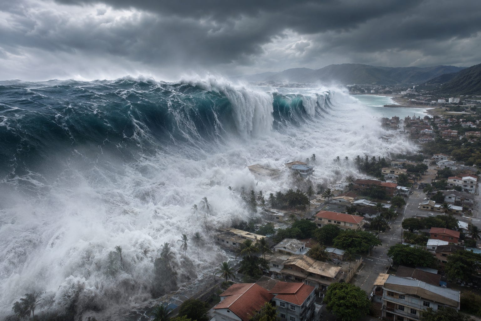
The transformation of an open-ocean tsunami into a coastal catastrophe is governed by the physics of wave shoaling — the dramatic amplification that occurs as waves encounter shallower water. As water depth decreases, wave speed drops according to the shallow-water wave formula. The wave’s period remains essentially constant (energy conservation), but as it slows, its wavelength compresses and its height grows — a process akin to an accordion being compressed. Wave heights that were less than a meter in deep water can grow to 10, 20, or even 40 meters at the shoreline, depending on the geometry of the coast and the seafloor.
The leading edge of a tsunami train often manifests as a dramatic withdrawal of water from the shore — the sea drawing back like a giant inhalation before the crest arrives. This happens when a trough precedes the first wave crest. Tragically, this phenomenon has drawn curious onlookers onto exposed seabeds, only for the crest to arrive minutes later with lethal force. The 2004 Indian Ocean tsunami killed an estimated 227,898 people across 14 countries — a death toll that underscores both the physical power of these waves and the critical importance of early warning and public education.
The Role of Geological Complexity
Real earthquakes and tsunamis are never as clean as idealized models suggest. Geological complexity — the heterogeneous structure of faults, the variability of coastal bathymetry, the presence of submarine canyons and ridges — dramatically shapes how seismic energy is released and how tsunami waves propagate and interact with coastlines.
5.1 Fault Heterogeneity and Slip Distribution
A major earthquake does not rupture its fault uniformly. Instead, slip is concentrated in high-slip ‘asperities’ — patches of the fault with particularly strong coupling — while other portions of the fault slip less or not at all. This heterogeneous slip distribution creates a complex spatial pattern of seafloor deformation, which in turn generates a tsunami with a complicated, multi-peaked wave train rather than a simple solitary wave.
The 2011 Tōhoku earthquake was remarkable for the extraordinary amount of slip concentrated near the trench axis — in some regions exceeding 50 meters, far beyond what seismic hazard models had anticipated. This shallow, near-trench slip was particularly effective at generating tsunami energy, partly explaining why the resulting tsunami was disproportionately large relative to the earthquake’s magnitude. This discovery has fundamentally revised estimates of tsunami hazard at other subduction zones worldwide.
5.2 Bathymetric Effects and Coastal Geometry
The behavior of tsunami waves as they approach coastlines is profoundly shaped by underwater topography (bathymetry) and coastal geometry. Submarine ridges and seamounts can refract tsunami energy, focusing it onto particular stretches of coastline and creating localized amplification. Coastal embayments and submarine canyons can act as resonance chambers, trapping wave energy and producing sustained, repeated inundation long after the initial waves arrive.
The town of Miyako, on Japan’s Sanriku Coast, recorded run-up heights of up to 40 meters during the 2011 event — nearly double the regional average — largely due to the funneling effect of the local coastal geometry and the channeling of energy through the Ryori Bay. Understanding this spatial variability requires high-resolution bathymetric and topographic data and sophisticated numerical modeling to accurately forecast where tsunami energy will be concentrated.
Human Vulnerability and Scientific Mitigation
The physical forces described in this essay are ultimately indifferent to human civilization. What transforms a geological event into a human catastrophe is the intersection of natural hazard with human vulnerability: where people live, how their buildings are constructed, and how quickly they can be warned and evacuated. The science of seismology and tsunami physics has made enormous strides in understanding, but translating that understanding into reduced mortality requires sustained investment in monitoring, infrastructure, and public preparedness.
6.1 Seismic and Tsunami Warning Systems
The Pacific Tsunami Warning Center, established in 1949 following the devastating 1946 Aleutian tsunami, now operates as part of a global network of monitoring infrastructure. Modern systems integrate seismographic networks that detect and characterize large earthquakes within minutes, networks of DART (Deep-ocean Assessment and Reporting of Tsunamis) buoys that measure actual tsunami wave heights in real time, and tide gauge networks that provide coastal observations. Together, these systems can issue warnings to distant coastlines within 10–15 minutes of a triggering earthquake.
The critical challenge is the near-field problem: for communities located close to the tsunami source, the waves may arrive within minutes — far too quickly for any centralized warning system to provide adequate lead time. In these cases, the earthquake itself must serve as the warning signal. Seismic education programs teach coastal residents that strong or prolonged ground shaking is a natural tsunami warning: do not wait for an official alert — move immediately to high ground.
6.2 Engineering Resilience and Land-Use Planning
Beyond warning systems, long-term resilience requires engineering adaptation and thoughtful land-use planning. Seismic-resistant building codes — derived from decades of post-earthquake reconnaissance and structural engineering research — have demonstrably saved lives in countries like Japan, New Zealand, and Chile. Vertical evacuation structures, specially engineered buildings, and artificial mounds designed to serve as refuges when horizontal evacuation is impossible, represent a practical response to near-field tsunami risk in low-lying coastal communities.
Land-use planning — restricting development in known tsunami inundation zones, preserving natural coastal buffers such as mangrove forests and barrier dunes, and designing coastal cities with clear evacuation corridors — addresses the root cause of tsunami mortality: the proximity of vulnerable people and infrastructure to hazardous zones. These are not merely engineering challenges; they are questions of governance, economics, and social equity that science alone cannot resolve.
Living with an Active Planet
Earthquakes and tsunamis are not aberrations. They are expressions of the same planetary processes that built the continents, shaped the ocean basins, and created the conditions for life. The subduction of the Juan de Fuca plate beneath North America, the convergence of the Indian and Eurasian plates along the Himalayan front, the slow creep of the Pacific Plate past the North American Plate along the San Andreas system — these are not geological curiosities. They are ongoing chapters in a story that began with Earth’s formation 4.5 billion years ago and will continue long after human civilization has run its course.
What has changed — what makes the modern era different from all the millennia of geological history before it — is that we now possess the scientific knowledge to understand these forces, to measure them, to model them, and increasingly, to anticipate their consequences. The challenge of the 21st century is not to discover that these forces exist — that much is certain — but to build societies sophisticated enough to coexist with them, informed enough to respect them, and resilient enough to survive them.
The hidden forces behind earthquakes and tsunamis are hidden no longer. They operate in the open, described by equations, mapped by satellites, and recorded by thousands of sensors spanning the globe. The question is not whether the next great earthquake will come. It is whether we will be ready.

Selected References & Further Reading
Stein, S. & Wysession, M. (2003). An Introduction to Seismology, Earthquakes, and Earth Structure. Blackwell Publishing.
Scholz, C.H. (2002). The Mechanics of Earthquakes and Faulting (2nd ed.). Cambridge University Press.
Satake, K. (2014). ‘Advances in earthquake and tsunami science and disaster risk reduction since the 2004 Indian Ocean tsunami.’ Geoscience Letters, 1(1), 1–13.
Lay, T. et al. (2011). ‘Possible large near-trench slip during the 2011 Mw 9.0 off the Pacific coast of Tohoku earthquake.’ Earth, Planets and Space, 63, 687–692.
Atwater, B.F. et al. (2005). The Orphan Tsunami of 1700. U.S. Geological Survey Professional Paper 1707.
National Oceanic and Atmospheric Administration (NOAA). Tsunami Preparedness and Hazard Mitigation. Available: https://www.tsunami.noaa.gov
Kanamori, H. (1977). ‘The energy release in great earthquakes.’ Journal of Geophysical Research, 82(20), 2981–2987.
Bryant, E. (2014). Tsunami: The Underrated Hazard (3rd ed.). Springer International Publishing.
Buy me a coffee www.paypal.me/adrianmcvey